History of Port Stephens is long and rich with colour. Port Stephens is the submerged estuary of the Karuah and Myall Rivers.
Aboriginal tribes known as the Worimi first inhabited the region. The Worimi consisted of the Grewerigal, Gamipinigal and Maiagal tribes that lived on the waters edge around the port. The existence of the Worimi in the area is evident in the occupational sites and artifacts left behind such as scar trees and shell middens.
Early development of Port Stephens
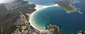
An idyllic coastal Paradise where the emphasis is on pleasure. From the early history of Port Stephens typified by volcanic peaks along the coastline to crystal clear bays fringed by golden sand, Port Stephens has lots to offer.
Captain James Cook in the Endeavour, sighted the entrance on 11th May 1770 and named the bay after the Secretary of the Admiralty. It was first entered in 1791 by the British ship “Salamander” from the Third Fleet, and surveyed in 1795 by Charles Grimes.
Later that same year, Captain W.R. Broughton turned the HMS Providence into Port Stephens and was shocked to find five whites living with the Worimi. These turned out to be five convicts who had escaped from Parramatta, which lies near Sydney. They had shipwrecked at Port Stephens in 1790. They were welcomed into the tribe by the Worimi, who gave them wives and took them along on their wanderings.
During the early history of Port Stephens, the area was a haven for convicts escaping from Sydney. This led to the establishment of a garrison in 1820, which today is known as Soldiers Point. The area continued to grow throughout the 1800s.
Early shipping of timber and wool to Sydney commenced in 1816 with Capt Corlette in his 62 ton cutter “Lambton”. The Australian Agriculture Company carried produce from the hinterland to North Arm Cove from 1824, and there was a timber mill at Winda Woppa. They operated “Karua”, one of the first steamers in Australia. Whalers were frequent visitors.
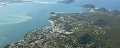
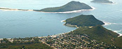
Port Stephens Landmarks
Broughton Island
Named after Captain Broughton, who sheltered at Port Stephens in 1795 after crossing from South America in the Providence.
Cabbage Tree Island
The only breeding place for Gould’s petrel.
Carrington
First settlement of the Australian Agricultural Company which was set up in 1824 to “produce wool of the finest quality in New South Wales for the markets of Great Britain …”. By 1830 Carrington had a population of 500 and a school for 50 children. This was the first school built in Port Stephens. Port Stephens’ first hospital was also situated at Carrington. Site of the former Holy Trinity Anglican Church, the first church in Port Stephens – built by convicts from stone, cemented with lime obtained from oyster shells, and with cedar fittings (later used as a youth hostel). The oldest grave in the cemetery at Carrington dates back to 1837. The general layout of Carrington is much the same today as it was in the past. Site of memorial to William Cromarty erected by A.A. Co. The A.A. Co. was also responsible for establishing vineyards at Carrington and the first wine was successfully produced in 1831.
Hawks Nest
Supposedly named because of the hawks that nested in a large tree used as navigational marker.
Karuah
During the time of the Australian Agricultural Co. Karuah was known as Sawyers Point because logs from up the river were sawn up here.
Legges Camp Guest House
The two storied guest house was completed in 1927. Much of the timber for the guest house was salvaged from the sunken drogher, ‘Bellbird’. Provided accommodation for 70 people, who came to the Myall Lakes for game hunting and fishing. The 29k track to Big Gibber and Seal Rocks was constructed between 1934 and 1936 by Harry Legge and his sons, Ron and Allan. The track was created without destroying trees.
Mungo Brush
Mungo Brush was the name given to the coastal rain forests which once contained cedar. Still remaining are paper barks, cabbage palms and red gums. The Mungo Brush Regatta commenced in 1909, a three day social event for the people of the lakes with visitors coming from Sydney, Newcastle and elsewhere.
Myall Lakes
Myall Lakes is an Aboriginal word meaning ‘wild’. Aboriginal shell middens occur frequently along the coast and on Broughton Island. Excavation has revealed the bones of dingoes and macropods as well as fishbones, shells and implements. Human skeletons have also been found. White settlement reduced the Aboriginal population.
There was a substantial timber trade on the lakes. Cedar trade commenced in 1816 and was well established by the early 1820s. In the early 20th Century the residents of the Myall Lakes could travel only by water. Supplies were brought in by the storeboat “Nepean” travelling from Tea Gardens around the lakes. The vessel carried food, medicine, clothing, hardware etc. Mining for mineral sands commenced in the late 1960s. In 1972 Myall Lakes National Park, a small area on the eastern side of Myall Lakes, was established. Mined areas were revegetated. The national Park was extended in 1976 to include the western side of the lakes. All sand mining in the National Park ceased in 1983.
North Arm Cove
North Arm Cove was the site for Walter Burley Griffin’s great city (the New York of Australia), planned in the expectation that Port Stephens would become the main seaport for New South Wales. The land was purchased by Henry F. Haloran, land developer and surveyor, but the city never eventuated. Plans for the city show two railway stations, a business district, Federal and State office sites, a factory district, car parks, wharves, parks and playgrounds. The subdivision commenced in 1918, the outline of which can still be seen from the air.
Pindimar
Pindimar is an Aboriginal name meaning ‘Black Possum’. The site was proposed for the development of Pindimar City as a port for overseas shipping in 1918. Pindimar was also the suggested site of a naval base for the Pacific Fleet by Admiral of the Fleet, Viscount Jellicoe, in 1919. The proposed city was designed by W. Scott Griffiths and covered an area of 7000 acres. Plans for the development included farming lots for returned soldiers, a railway link, industrial and educational zones, a cathedral, golf links and cemeteries. The proposal was later rejected and the city never eventuated. A shark catching and processing station opened in 1927 and was later converted into an ice factory.
Tahlee House
Tahlee House was originally built of sandstock brick in 1826 for Robert Dawson, the first manager of the Aust. Ag. Co. and home to the first four commissioners of the A.A. Co. The house was destroyed by fire in 1860. The Hon. R.H.D. White, a Sydney stockbroker, purchased Tahlee in 1880 and built a new residence on the remains of old, utilising the remaining walls. The home featured a beautiful garden, ball room and tennis courts and was the centre of extravagant hospitality, entertainment and general carousing. The boat harbour at Tahlee was originally built by convicts.
Tamboi
Tamboi was an old fishing village. Setting for the novel February Dark by Ann Von Bertouch.
Tea Gardens
Chinese gardeners tried unsuccessfully to grow tea in the Tea Gardens region in the time of the Aust. Ag. Co. It later became a shipping point for cedar from the Myall River and Lakes area. The site of limekilns used for the burning of shells from aboriginal middens.
Winda Woppa
Site of the first timber mill built in 1920.
 Towns
Towns Attractions
 Hotels